Theedway in the Bedfordshire Landscape
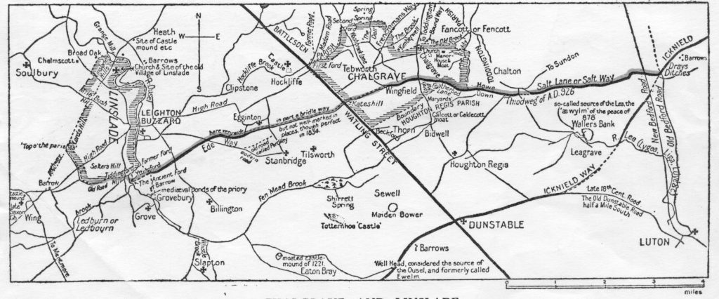
An important routeway crossing Saxon Bedfordshire for 12 miles was Theedway, possibly of Neolithic origins. It diverged from the Icknield Way north of Luton at the foot of Warden Hill to head westwards towards the River Ousel which it crossed south of Linslade at Yttingaford (now Tiddenfoot), the site of Edward the Elder’s peacemaking with the Danes in 906. Yttingaford is mentioned on the boundary of an estate at Linslade in a charter dating from 966 which also describes Theedway as the southern boundary of this estate (later parish). A charter for Chalgrave dating from 926 also refers to Theedway where it coincided with part of what became the parish boundary. Theedway was utilised to define several other parish or township boundaries across the county, showing it to have been a prominent feature in the landscape when such boundaries were established before or during the 10th century. Its influence is still visible today: the northern boundary of Luton Borough was established along Theedway at least a millennium ago and is the present limit of the built up area.
Theedway was linked by the Icknield Way to salterns on the East Anglian fen edges and became a routeway for transporting salt in Saxon and medieval times, hence the names Saltstrete Way in Linslade recorded in 1511, Salters Hill nearby and Salters Well in Eggington. Theedway also influenced settlement: when Clipstone’s expansion during early medieval times was hindered by streams and topography a large green was laid out to the south along the north side of Theedway and a single row village built along its northern edge – Eggington.
Later, Theedway’s significance as a routeway for trade or travel declined and it gradually fell out of use. Today only a few short stretches remain as footpaths.
Stephen Coleman May 2007