Public Rights of Way (PRoW) are continually changing. Just like other highways there is a formal process to follow to change the Definitive Map (see home page) which can take years.
Toddington Multi-Access Forum
In 2021 a number of local folk have formed the TMAF The object is to “work together to create a joined up and safe network of Rights of Way around the local parishes to enable non-motorised users to have safe, accessible circular routes on bridleways, byways and quiet roads. ” More information
Changes in progress
The following changes are at various stages of development. If anyone has comments or evidence to support these changes then please contact me.
Battlesden boundary
This was formally lodged with Bedfordshire County Council in June 2006. It seeks to join the gap in the footpath network on the Toddington/Battlesden/Milton Bryant parish boundaries. See details under Battlesden on CBC website.
Westoning boundary
This was formally lodged with Bedfordshire County Council in April 2008. It seeks to upgrade the footpath to bridleway and to realign the route on the Toddington/Westoning parish boundary. See details under Westoning on CBC website.
Fancott (TOD61)
The path near Stockwell Farm House has not followed the legal line for many years. Up until 2021 the used route included one of the last of two remaining stiles in Toddington. The owners have proposed a slightly different alignment through the woodland and further away from the houses. This is now progressing and as of early 2021 the consultation had not received any formal objection. The formal Order was sealed to make the changes on 1st April 2022. Assuming no challenges by the 13 May 2022 then this will be formalised. The new route is already in use.
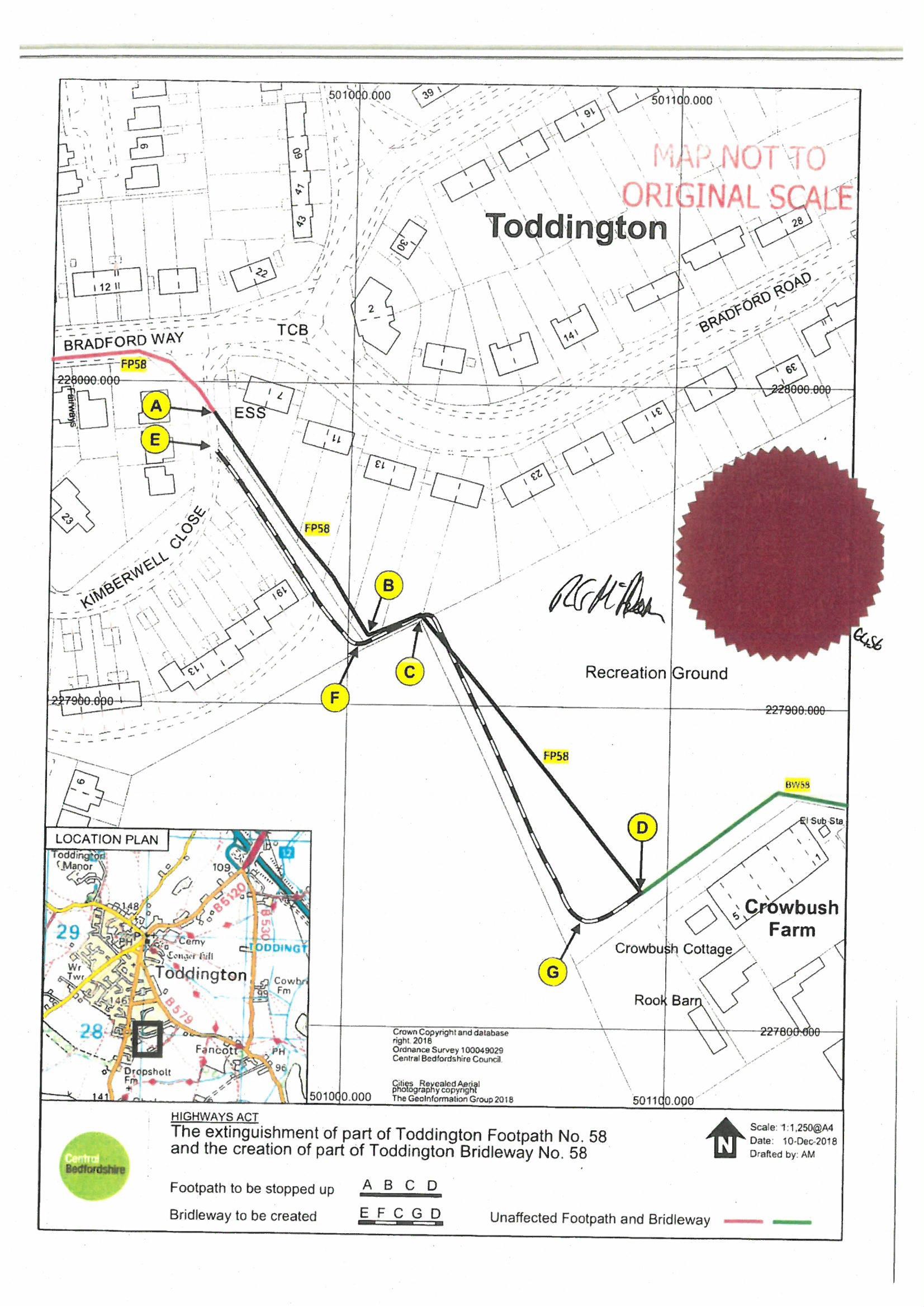
Crowbush
This (TOD58) has been an anomaly for many years. The Definitive Map shows the footpath running through the rear gardens of eight houses in Bradford Road. The 2019 proposal would take it out of all but a couple of gardens. It would resolve the legal anomaly that may cause difficulty for any of the eights houses to be sold. Alternative proposals to use the adjacent field edge were explored but rejected by the landowner. The 2019 proposals resulted in an unresolved objection, as a result the proposals were sent to the planning inspector in the summer of 2020 for determination. See details under Toddington on CBC website. In December 2021 the Planning Inspector published his decision to overrule the householder objection and to confirm the 2019 published order. Anticipate work to open up the new route and formally close the old route in the new year – see news item from Feb 2022.
Grove Farm
In 2020 the owners of Grove farm, Houghton Regis (east of Lords Hill) created an new route for the bridleway through their land. They are progressing this as a formal change. The legal route is still formally accessible but the owners would prefer users to use the proposed route. More information.
Tebworth Solar Farm
The Tebworth Solar farm has a proposed site in fields between Toddington and Tebworth. Details are available on the scheme website.
Paths which are not usable
There are several paths on the Definitive Map which are legal rights of way but in practice are not usable. More information.